Reality. Quantified.
Physical assets decay quietly. StreetMirror makes their condition visible at city scale — so you can fix what matters.

POC — OOH
Ground truth on every advertising face.
An independent, city-wide census of OOH. Sandton, live now. No sign-up.
Media owners, media agencies and the brands that buy from them all plan against the same problem: nobody has independent, ground-truth data on what is actually on the road, where it sits, and whether it is still doing its job. Pricing happens on proxies. Performance reports come from the same companies that placed the boards. Real-world reality is invisible.
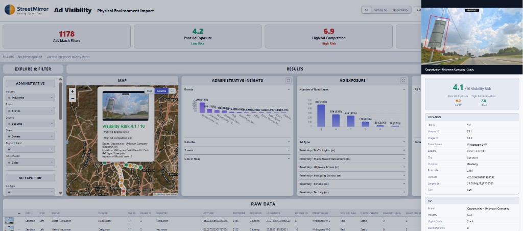
StreetMirror runs structured visual censuses across entire cities, turning the observable condition of every advertising face into structured, comparable data. The Sandton POC is the first time anyone has put that data in front of the industry: every panel's location, the lanes it covers, the traffic context that shapes visibility — and, on the paid tier, the actual roadside condition of each face. Independent. Repeatable. City-wide.
The data is built to plug in, not replace. Export it cleanly into the analytical and AI models your team already runs — planning tools, audience models, ROI calculators — and feed them the rich physical-world reality they have never had access to before.
If this existed every month in your market, would you use it?
Physical Impact
Visibility shaped by the physical world.
- What it shows
- Every advertising face in the city, plotted with the physical-world signals that drive visibility — lanes, traffic context (intersections, highway access, schools, shopping centres), and how crowded each spot is with other OOH. The reality of the environment around each board.
- Best for
- Planning, network audits, competitive mapping, market sizing — and as a feed into existing audience and ROI models.
- Refresh
- Snapshot of the current Sandton POC.
- Export
- PDF, Excel, PowerPoint — full filtering. Built to drop into existing analytical pipelines.
- Cost
- Free. For everyone. Forever.
Actual Ad Condition
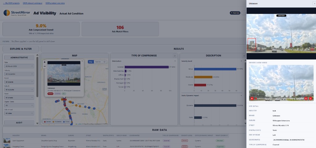
What each face is really doing on the road.
- What it shows
- The real-world condition of each face — visible, blocked, damaged, mis-aligned. Plus brand-aware competition: how many of your competitors are within 300 m of any given site, by industry.
- Best for
- Buying with confidence, defending inventory quality, closing the planned-versus-actual gap with shared evidence.
- Refresh
- Quarterly re-walks. Decline, recovery and trend lines tracked over time.
- Export
- Same as Free, plus brand-context overlays.
- Cost
- Priced so the whole industry can use it — not just the biggest budgets.
Free. Opens directly in Physical Impact view.
POC — Banks & Insurance
Ground truth on every covered asset.
An independent, city-wide census of residential and business asset condition. Greenhills, captured 2025.
Banks finance the asset at origination. Insurers price it at binding. After that, the asset is invisible — until a claim, a default, or a revaluation forces a one-off site visit. The condition that drives value, risk and loss severity is captured nowhere, by nobody, between those events.
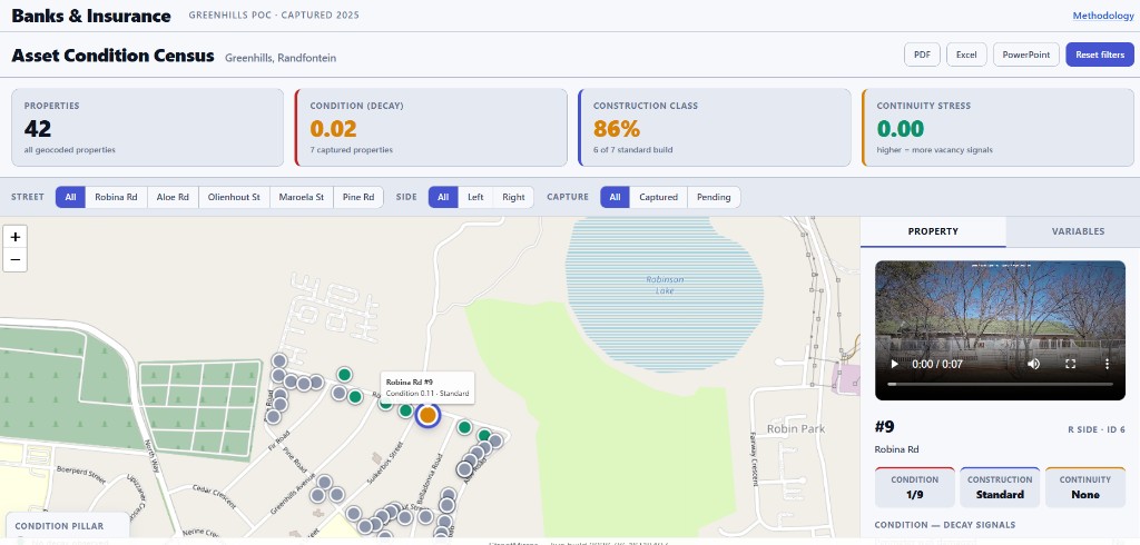
StreetMirror walks the street. Every house and business is scored on the same three pillars — Condition, Construction, Continuity — using atomic, photo-verifiable observations grounded in Fannie Mae UAD, broken-windows research and SA insurance construction-class tables. Independent. Repeatable. City-wide.
If you could see street-level asset condition across your book every month, what would you decide differently?
Asset Condition Census
3C scorecard per property: Condition, Construction, Continuity.
- What it shows
- Every residential and business property on a captured street, scored on the 3C model — the decay signals that drive Condition, the construction class that drives insurance pricing, and the occupancy signals that drive Continuity.
- Best for
- Portfolio condition monitoring between site visits, claims triage, construction-class auditing, early signal on neighbourhood-level value drift.
- Refresh
- Snapshot of the current Greenhills POC.
- Export
- PDF, Excel, PowerPoint — full filtering, ready to plug into existing portfolio risk models.
Email-gated. Manual access by the StreetMirror team. Methodology available.
Measure the Physical World
A consistent pipeline from capture to insight — built for portfolios, not once-off inspections.
Capture
Visual census of the physical environment.
Quantify
Condition indicators and scoring.
Track
Ongoing monitoring and trends.
Data-Driven Insights for Multiple Asset Classes
OOH Exposure

Surface hidden underperformance in outdoor advertising networks.
Urban Degradation
Track CBD decline and recovery with one consistent lens.
Property Integrity

Bring portfolio exteriors into one scored, comparable view.
Agricultural Risk

Prioritise fence and boundary repairs before exposure grows.
Unlock City-Scale Intelligence
Based in Johannesburg, South Africa
Transform how you manage and maintain your urban environment with regular, data-driven insights from StreetMirror.
info@streetmirrorapp.com